
Beyond the Char Dham: 7 Ancient Temples in Uttarakhand You’ve Never Heard Of
March 20, 2026
The history of Uttarakhand is shaped by two ancient sacred regions: Kedar Khand and Manas Khand. These territories, rooted in scriptural texts dating back to the 6th century BCE, have defined the state’s cultural and geographical identity for millennia. Kedar Khand includes the Garhwal region with its revered Kedarnath and Badrinath shrines. Manas Khand covers the Kumaon area, home to Jageshwar and Purnagiri.
We’ll explore how Uttarakhand’s geography, dynastic rule, and cultural history evolved separately in these regions before merging into one state in 2000.
Ancient Origins and Scriptural References
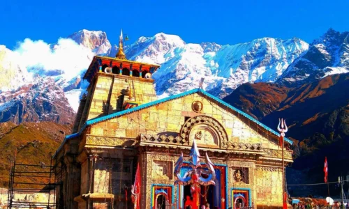
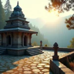
Image Source: Facebook
Kedarkhand in Skanda Purana and Ancient Texts
The Skanda Purana stands as the largest Mukhyapurana among the eighteen Hindu religious texts and contains over 81,000 verses of Shaivite literature. The Kedara Khanda has 35 chapters dedicated to the Kedarnath Tirtha region in North India. This section forms part of the Maheswara Khanda, which is subdivided into three Upa Khandas: Kedara, Kaumarika and Arunachala.
The earliest Skanda Purana text existed by the 8th century CE and functioned as an encyclopedic travel handbook with meticulous pilgrimage guides. The Kedara Khanda describes regions from Gangadwara (Haridwar) to the greater Himalaya and establishes this zone as a living sacred landscape. Hindu scriptures refer to the western portion of Uttarakhand as Kedarkhand, which corresponds to present-day Garhwal.
Manaskhand in Puranic Literature
Puranic literature identifies Manaskhand as the ancient designation for the Kumaon Himalaya. The Skanda Purana contains references to both Kedarkhand for Garhwal and Manaskhand for Kumaon. Ancient texts describe Manaskhand as extending through the Kali River valley and representing the eastern section of what we now recognize as Uttarakhand.
The nomenclature Manaskhand persisted through historical periods and later transformed into Kurmanchal before settling on its current designation of Kumaon. Sanskrit literature pairs these two regions and treats them as complementary geographical and spiritual entities within the central Himalayan stretch.
Timeline: 6th Century BCE to 3rd Century BCE Mentions
Historical evidence places mentions of these sacred regions in early Hindu scriptures, with references spanning from the 6th century BCE onward. Both Kedarkhand and Manaskhand names were prevalent during the Mahabharata period, when the entire region fell under unified suzerainty. Ancient texts like the Aitareya Brahmana reference the region as Uttarkuru, while Buddhist literature mentions it as Himvant.
The boundary demarcation between these territories remained consistent across scriptural sources and divided the land from Haridwar to Mansarovar into two distinct parts. This region operated under a unified administrative system at the time of Vaishnavas and earned the collective designation Narayani Kshetra or Devbhoomi.
Geographic Boundaries Defined in Sacred Texts
Sacred texts establish precise geographic parameters for both regions. Kedarkhand extends from Gangadwara (Haridwar) in the south to the Shvetang Parvat (Himalaya) ranges in the north and spans from Baudhanchal (possibly Badhan Patti) in the east to Tamasa (Tons) river in the west. This demarcation covers the regions of Garhwal, Dehradun and Haridwar as they existed before the eighth or ninth century.
Manaskhand’s boundaries stretch from the Tons (Tamsa river) in the west to the Kali (Sharda) river in the east. The division between these sacred territories follows natural river systems and creates a clear separation between western and eastern Kumaon.
Geographical Extent and Natural Features
Kedarkhand: Gangadwara to Shvetang Parvat Range
Uttarakhand’s total geographical area spans 53,483 square kilometers. Mountainous terrain has approximately 86 percent of this expanse at 46,035 square kilometers. Kedarkhand occupies the western portion and stretches from Gangadwara (Haridwar) in the south to the Shvetang Parvat (Himalaya) ranges in the north. The region extends from Baudhanchal in the east to Tamasa (Tons river) in the west. This region covers the historic 52 forts area, which gave rise to the name Garhwal.
Kedarkhand’s geography of uttarakhand varies in elevation. Bhabar and Terai plains make up 14 percent of the state’s area at lower elevations and cover 7,448 square kilometers. The Himalayan peaks reach great heights, with Nanda Devi standing as the second highest mountain in India. The Kedarnath peak rises to 6,940 meters. Kedar Dome flanks it at 6,831 meters. Forest wealth covers 45.44 percent of the region, approximately 24,303.04 square kilometers. These forests range from alpine grasslands to deciduous forests.
Manaskhand: Kali River Valley to Eastern Boundaries
Manaskhand represents the eastern section and divides into western Kumaon and eastern (Kali) Kumaon. The region extends through the Kali River valley and forms natural boundaries that separate this sacred zone from Kedarkhand. The area covers over thirty peaks rising above 5,500 meters within a tract measuring merely 225 kilometers in length and 65 kilometers in breadth.
The Kali River originates at Kalapani at 3,600 meters elevation and descends to 200 meters upon entering Terai plains. This river, also known as Sharda or Mahakali, runs 252 kilometers with a basin area of 18,140 square kilometers.
River Systems: Ganga vs. Kali and Tributaries
Ganga’s tributaries Bhagirathi and Alaknanda define Kedarkhand’s river network. Bhagirathi originates at Gaumukh from Gangotri Glacier and meets Alaknanda at Devprayag. The Mandakini flows from Chorabari Glacier near Kedarnath and joins Alaknanda at Rudraprayag. Yamuna emerges from Yamunotri glacier.
Manaskhand’s river system centers on the Kali and its tributaries. The Kali receives Dhauliganga at Tawaghat and Gori Ganga at Jauljibi. Additional tributaries are Chameliya, Saryu, Ladhiya, and Ramgun. The Pindari glacier in Bageshwar district sources the Pindar river.
Mountain Peaks and Valley Formations
The Trishul mountain group has three peaks named after Lord Shiva’s trident. Badrinath and Kedarnath ranges hold religious significance within the Char Dham pilgrimage circuit. Soft grasslands called Bugyal and Payal have formed between these mountain ranges. Rivers have carved many valleys and passes and created fertile plains known as Doon.
Present-Day Districts Coverage: 7 vs. 6 Districts
Garhwal division has seven districts: Chamoli, Dehradun, Haridwar, Pauri Garhwal, Rudraprayag, Tehri Garhwal, and Uttarkashi. The Kumaon division has six districts: Almora, Bageshwar, Champawat, Udham Singh Nagar, Pithoragarh, and Nainital. This administrative structure reflects the historical division between Kedarkhand and Manaskhand in the cultural history of uttarakhand.
Historical Dynasties and Political Evolution
Kedarkhand: Katyuri Rule (6th-12th Century)
The Katyuri dynasty emerged as a medieval kingdom ruling Uttarakhand from either 500 to 1200 CE or 700 to 1200 CE. Vashudev Katyuri founded the dynasty and ruled from Joshimath in the Alaknanda Valley at first. He later changed the capital location to Baijnath. The Katyuris called their realm Kurmanchal and linked it to the Kurma avatar of Vishnu.
The Katyuri dynasty at its peak extended from Sikkim in the east to Kabul, Afghanistan. They dominated lands from the Katyur valley in Kumaon between the 7th and 11th centuries. Kartikeyapura (modern Baijnath) became their political and religious center. King Bhu Dev eradicated Buddhist practices extensively and wrote himself as ‘Brahmana Parayana’. The dynasty fragmented into smaller branches including Askot and Doti after the 11th century.
Manaskhand: Chand Dynasty Dominance
Som Chand created the Chand dynasty in the early 11th century and replaced the declining Katyuri rulers. He originated from Jhusi near Kannauj. His capital was set at Rajbunga in present-day Champawat. The Chands claimed Somavanshi descent and identified as Rajputs.
Raja Kalyan Chand changed the capital to Almora in 1563. He founded a town named ‘Alam Nagar’. Baz Bahadur Chand (1638-78) met Shahjahan in Delhi. He joined forces with him in 1655 to attack Garhwal and captured the Terai region including Dehradun. The Chand rule ended in 1790 when Gurkhas invaded Kumaon and forced the last king Mahendra Chand to flee.
52 Principalities of Garhwal vs. Kumaon Kingdoms
Garhwal consisted of 52 petty chieftainships at the start, each with independent fortresses. Raja Ajay Pal unified all minor principalities in 1358 and founded the Garhwal Kingdom. The Chand dynasty managed to reunify Kumaon in the middle of the 15th century after three centuries of fragmentation.
British Era: Separate Administrative Units
The British ruled Kumaon and Garhwal for thirteen decades following the Treaty of Sugauli on 21 April 1815. The districts were renamed Almora, Nainital and British Garhwal in 1892. Kumaon-Garhwal was administered as a Non-Regulation province under hand-picked commissioners who exercised both executive and judicial powers.
Formation of Modern Uttarakhand (2000)
Uttarakhand emerged as the 27th state of India on 9 November 2000. The state was named Uttaranchal at first but was renamed Uttarakhand in 2007. The demand started in the 1930s during the British era and intensified in the 1990s due to cultural differences and geographical isolation from Uttar Pradesh.
Cultural Heritage and Religious Significance
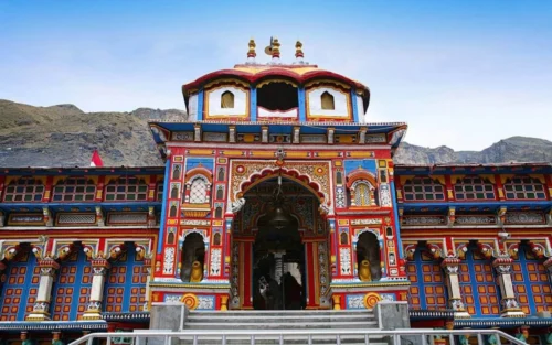
Image Source: Bon Travel India
Kedarkhand’s Sacred Sites: Kedarnath and Badrinath
Religious pilgrimage defines Kedarkhand’s spiritual landscape. The region centers around Kedarnath Temple, one of twelve Jyotirlingas dedicated to Lord Shiva. The temple stands at 3,584 meters near Chorabari glacier and features a conical rock formation worshiped as Sadashiva. The Panch Kedar circuit extends this sacred geography and comprises five temples where different parts of Shiva manifested: Kedarnath (hump), Tungnath (arms at 3,680 meters), Madhyamaheshwar (navel at 3,289 meters), Rudranath (face at 2,286 meters), and Kalpeshwar (hair).
Badrinath Temple complements this Shaiva tradition. Dedicated to Lord Vishnu, it perches at 3,415 meters on the Alaknanda riverbanks. These shrines anchor the Char Dham pilgrimage circuit and establish Kedarkhand as a primary destination in the history and culture of Uttarakhand.
Manaskhand’s Pilgrimage Centers: Jageshwar and Purnagiri
Jageshwar represents Manaskhand’s architectural and spiritual pinnacle. The site comprises over 100 stone temples dedicated to Lord Shiva. The complex showcases structures from the 7th to 14th centuries. Local traditions call the main shrine one of twelve Jyotirlingas. King Katarmal of the Katyuri dynasty constructed the Katarmal Sun Temple between the 6th and 9th centuries. It stands as the second largest Surya temple in India.
Purnagiri Temple functions as one of 108 Shakti Peeths, where Sati’s navel is believed to have fallen. The Uttarakhand government’s Manaskhand Mandir Mala Mission develops 16 puranic temples across Kumaon. These include Naina Devi, Patal Bhubaneswar, and Chitai Golu Devta.
Folk Traditions: Garhwali vs. Kumaoni Culture
Kumaoni culture stands out through Aipan art. These geometric patterns decorate walls and cloth and represent gods and nature. Pichhaura, traditional attire worn during religious occasions, uses vegetable dyes in red and saffron. Kumaoni Holi is a month-long musical affair that spans Baithki Holi, Khari Holi, and Mahila Holi variations.
Garhwali traditions emphasize Jagar, ritualistic spirit invocations performed through folk songs. Garhwalis celebrate Bissu Mela and Gora-Maheshwar festivals. Kumaonis observe Phool Dei, Bhitoli, and Hill Jatra rooted in agricultural cycles.
Architectural Styles: Temple Construction Methods
Both regions use Nagara architectural style, marked by curved spires and square sanctums. Kedarnath’s construction uses interlocking gray stone slabs without mortar and secures them by iron clamps. Jageshwar temples feature intricate stone carvings that follow North Indian Himalayan temple architecture.
Traditional Music and Dance Forms
Chholiya dance, over a thousand years old, involves 22 performers (8 sword dancers, 14 musicians). They execute synchronized mock battles during Rajput weddings. Jhora and Chanchari represent Kumaoni group dances performed in circles. Garhwali traditions include Pandav Nritya, a 10-12 day dance-drama that narrates Mahabharata episodes, and Langvir Nritya, an acrobatic performance atop bamboo poles. Jagar performances use 50 ballads that invoke local deities through Dhol, Damua, Hurka, and Thali instruments.
Modern Identity and Administrative Structure
Uttarakhand became the 27th state of the Indian Union on November 9, 2000, carved from Uttar Pradesh’s hilly regions. The movement for separation gained momentum in the 1990s, driven by aspirations of mountain communities who felt underrepresented by the larger state government. The Indian Parliament passed the Uttar Pradesh Reorganization Act in 2000 after years of protests and negotiations. This created an autonomous entity based on linguistic and regional identity principles.
The state was first named Uttaranchal and renamed Uttarakhand in 2007. Dehradun is the state capital, while Nainital functions as the judicial capital and houses the Uttarakhand High Court. The administrative framework mirrors the ancient Kedarkhand-Manaskhand division through two modern units: Garhwal and Kumaon.
Pauri is the administrative center for Garhwal division, where a Divisional Commissioner oversees operations. Nainital anchors Kumaon division’s administration in a similar way. Each division maintains distinct governance structures and operates under unified state leadership.
The state government has its own Chief Minister, legislative assembly and judiciary responsible for education, healthcare and law enforcement. Uttarakhand contributes five seats to Lok Sabha and three to Rajya Sabha and ensures representation in national decision-making.
Recent initiatives like the Manaskhand Mandir Mala Mission reflect efforts to preserve regional identity and promote development across both historic zones.
Kedar Khand vs. Manas Khand
| Attribute | Kedar Khand (Kedarkhand) | Manas Khand (Manaskhand) |
| Modern Region | Garhwal | Kumaon |
| Scriptural Source | Skanda Purana (Kedara Khanda – 35 chapters) | Puranic literature references |
| Historical Timeline | References from 6th century BCE onward | References from 6th century BCE onward |
| Geographic Boundaries (West-East) | Tamasa (Tons) river to Baudhanchal | Tons (Tamsa) river to Kali (Sharda) river |
| Geographic Boundaries (North-South) | Gangadwara (Haridwar) to Shvetang Parvat (Himalaya) | Extends through Kali River valley |
| Major River System | Ganga tributaries (Bhagirathi, Alaknanda, Mandakini, Yamuna) | Kali River and tributaries (Dhauliganga, Gori Ganga, Saryu) |
| Key Mountain Peaks | Nanda Devi, Kedarnath (6,940m), Kedar Dome (6,831m), Trishul, Badrinath | More than 30 peaks above 5,500m in 225km x 65km tract |
| Present-Day Districts | 7 districts (Chamoli, Dehradun, Haridwar, Pauri Garhwal, Rudraprayag, Tehri Garhwal, Uttarkashi) | 6 districts (Almora, Bageshwar, Champawat, Udham Singh Nagar, Pithoragarh, Nainital) |
| Dominant Dynasty (Medieval) | Katyuri Dynasty (500-1200 CE or 700-1200 CE) | Chand Dynasty (11th century – 1790) |
| Dynasty Founder | Vashudev Katyuri | Som Chand (early 11th century) |
| Historical Capital | Joshimath, then Baijnath (Kartikeyapura) | Rajbunga, then Almora (1563) |
| Political Structure | 52 petty chieftainships unified by Raja Ajay Pal in 1358 | Reunified in mid-15th century after fragmentation |
| End of Native Rule | Gurkha invasion (1790s) | Gurkha invasion (1790), last king Mahendra Chand fled |
| Primary Sacred Sites | Kedarnath Temple (Jyotirlinga), Badrinath Temple, Panch Kedar circuit | Jageshwar (100+ temples), Purnagiri Temple (Shakti Peeth), Katarmal Sun Temple |
| Main Deity Focus | Lord Shiva (Kedarnath) and Lord Vishnu (Badrinath) | Lord Shiva (Jageshwar) and Shakti (Purnagiri) |
| Temple Elevation | Kedarnath: 3,584m; Badrinath: 3,415m | Jageshwar: Lower elevation (elevation not specified) |
| Architectural Heritage | Panch Kedar temples, Char Dham circuit sites | 100+ stone temples (7th-14th centuries), Katarmal Sun Temple (6th-9th centuries) |
| Traditional Art Forms | Jagar (spirit invocations), Pandav Nritya, Langvir Nritya | Aipan art (geometric patterns), Pichhaura textiles |
| Festival Traditions | Bissu Mela, Gora-Maheshwar | Phool Dei, Bhitoli, Hill Jatra, Kumaoni Holi (month-long) |
| Dance Forms | Chholiya dance, Pandav Nritya, Langvir Nritya | Jhora, Chanchari (group circle dances) |
| Modern Administrative Center | Pauri (Divisional Commissioner) | Nainital (Divisional Commissioner and High Court) |
| British Era Name | British Garhwal (renamed 1892) | Almora and Nainital districts (renamed in 1892) |
| Modern Development Initiative | None | Manaskhand Mandir Mala Mission (16 puranic temples) |
Key Takeaways
Uttarakhand’s identity stems from two ancient sacred regions with distinct histories, cultures, and administrative structures that shaped the state’s formation in 2000.
- Ancient scriptural origins: Kedarkhand and Manaskhand were defined in 6th century BCE texts, with Kedarkhand covering Garhwal (western region) and Manaskhand encompassing Kumaon (eastern region).
- Distinct dynastic rule: Katyuri dynasty dominated Kedarkhand (500-1200 CE) while Chand dynasty controlled Manaskhand (11th century-1790), creating separate political and cultural identities.
- Sacred geography defines regions: Kedarkhand centers on Kedarnath-Badrinath pilgrimage sites along Ganga tributaries, while Manaskhand features Jageshwar’s 100+ temples and Purnagiri shrine along Kali River system.
- Modern administrative structure reflects ancient divisions: Today’s 7 Garhwal districts (Kedarkhand) and 6 Kumaon districts (Manaskhand) maintain the historical boundary between Tons and Kali rivers.
- Cultural heritage remains distinct: Garhwali traditions emphasize Jagar spirit invocations and Pandav Nritya, while Kumaoni culture features Aipan geometric art and month-long Holi celebrations.
Understanding these regional differences helps explain Uttarakhand’s rich cultural diversity and why the ancient Kedarkhand-Manaskhand division continues to influence the state’s identity, governance, and spiritual significance in modern India.